 Update, 9:45 am May 1: A short while ago, Malaysian Defense Minister Hishammuddin Hussein released the preliminary report on the disappearance of Malaysian Airlines Flight 370. This report was initially made to the International Civil Aviation Organization (ICAO) on April 9th, but had been withheld fr0m public release until now. While it contains little in the way of new information, it does confirm much of what had previously been reported. The report also confirmed that the 777 was tracked by military primary radar as it crossed the Malaysian Peninsula heading West. However, at the time the contact was classified by the operator as “friendly” so no further action was taken at that time. The report included one safety recommendation: that ICAO “examine the safety benefits of introducing a standard for real time tracking of commercial air transport aircraft.” You can read the preliminary report in its entirety below.
Alongside the preliminary report, the Malaysian government has been releasing several additional pieces of evidence and documentation. This includes maps of the confirmed and calculated track, the cargo manifest, and a complete passenger manifest that includes which seat each passenger was in. Also released was an audio recording of the communications between the missing aircraft and air traffic control. The Malaysian authorities have also begun urging all of the families of those onboard to return home, given the amount of time that the search has dragged on for.
[Not a valid template]
Update, 8:30 am April 14: Following six days without a confirmed signal detection, the Australian officials in charge of the search for Malaysian Airlines flight 370 have decided to move into the next phase of the search. Calling the four pings heard early last week the “most promising lead we have,” retired Air Chief Marshal Angus Houston as announced that search crews “need to pursue this lead as far as possible.” Careful analysis of the 4 pings that were heard has reduced the search zone to a “manageable area” for an undersea search. As a result, the crew aboard the ADV Ocean Shield will cease operations with the Towed Pinger Locator later today. They will also deploy the AUV Bluefin-21 as soon as possible.
Bluefin 21 will use its active side-scan sonar to map the ocean floor in missions lasting at least 24 hours each. Decent and ascent from the ocean floor will take 2 hours in each direction, with 16 hours of scanning the bottom on each mission. Data download and analysis is expected to take at least 4 hours at the end of each mission. There is no live streaming of the data that Bluefin-21 receives. The vehicle must surface and be retrieved by search crews before the data can be recovered.
This undersea search process is expected to be painstakingly slow, given the low speeds required by the AUV. The first search mission will only cover an area that is 5 km by 8 km, or roughly 15.5 square miles. Houston cautioned the media that this latest news should not raise hopes that the AUV would discover the remains of the missing aircraft. He stated that there is a good possibility that the sonar search would reveal nothing, but that the pings that were heard provided the best lead they have and that “it must be pursued vigorously.” However, Mr Houston further cautioned that we “don’t be overoptimistic,” and that we should “be realistic” about the prospects for a discovery.
While the search for floating debris continues, Mr. Houston cautioned that search will likely end in the coming days. Given the amount of time that has elapsed since the plane went missing, it has become highly unlikely that any floating debris will be recovered. the decision to abandon the search for floating debris will only be made after consulting Australia’s partners in the search, according to Houston.
Update, 8:00am, April 9: In an overnight press conference, Australian officials announced new

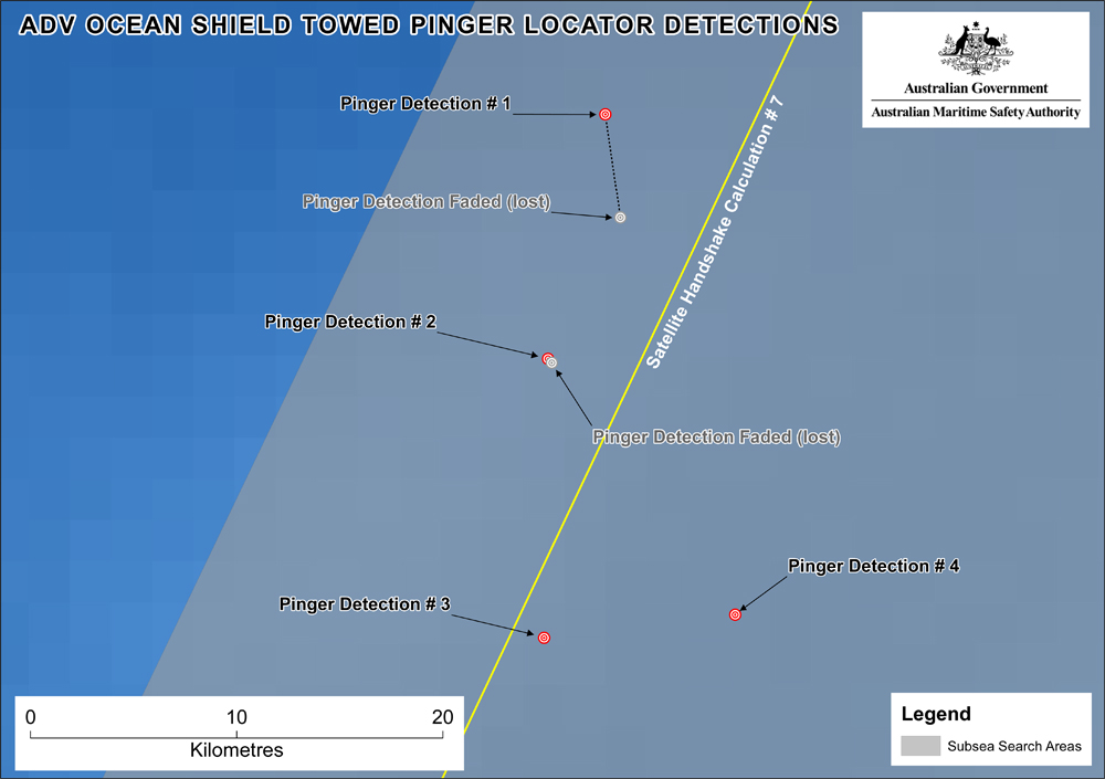
ADV Ocean Shield
developments in the search for MH370. Over the weekend two acoustic signals, commonly referred to as ‘pings’ were observed. Further analysis of these pings by the Royal Australian Navy (RAN) has confirmed that they are consistent with the signals that would be expected from the Flight Data Recorder (FDR) and Cockpit Voice Recorder (CVR). Yesterday, ADV Ocean Shield, operating the Towed Pinger Locator (TPL) on loan from the US Navy, reacquired signals consistent with those that would be emitted by the FDR and CVR. While this is currently day 33 of an expected 30 day lifespan of the batteries on the acoustic beacons, the Australian-led search teams plan to continue the acoustic search until they are certain that the batteries have been exhausted.
In addition to the use of the TPL, a Royal Australian Air Force (RAAF) P3C Orion will be dropping a line of sonobouys in the vicinity of the Ocean Shield in an attempt to provide more datapoints. That P3C has had modifications made to its acoustic processing equipment in recent days so that is can properly process the specific frequency of the pings. The sonobouys will deploy a hydrophone at a depth of 1,000 feet, which can also listen for acoustic pings. The TPL operates at a much greater depth, closer to the bottom of an area of ocean that is roughly 15,000 feet deep. Further ships will not be deployed in the acoustic search area, due to the need for extremely low levels of ocean noise.
The air- and surface-based visual search also continues, and that search area has been greatly refined in recent days to reflect the results of the acoustic search. However, no floating debris from the missing airliner have yet been found. More than a dozen aircraft, along with 18 surface ships, are participating in that part of the search.
 Once the Australian officials believe that the batteries in the acoustic beacons have been exhausted, an Autonomous Underwater Vehicle (AUV) will be deployed in an attempt to provide visual confirmation of the wreckage. According to Angus Houston, head of the Joint Agency Coordination Centre (JACC), the exact timing of that deployment has not yet been determined. However, he believes that the decision to deploy the AUV is not far off, since the signals received yesterday were believed to be quite weak. However, Houston cautioned that the AUV operates at a “walking pace,” making the search six times slower than searching with the TPL. Mr. Houston stressed that JACC will not consider the aircraft’s final resting place to have been found until there is visual confirmation of the wreckage. However, he was cautiously optimistic that the search is getting closer to pinpointing the location of the aircraft’s wreckage. Nonetheless, Mr Houston stressed that we may still be weeks away from receiving that visual confirmation.
The recent Australian ping detections have occurred along the line known as the ‘Seventh Transmission Line’. This is the line along which the widely reported “partial ping” was observed by Inmarsat. This partial ping was the final communication between the 777-200 and the satellite. Australian and Malaysian officials believe that this signal was transmitted as the aircraft’s engines flamed out due to fuel exhaustion.
Update, 6:15pm EDT, March 24: At 10:00pm local time last night in Kuala Lumpur (10:00am EDT), Malaysian Prime Minister Najib Tun Razak announced a major development in the search for Malaysian Airlines Flight 370. British satellite operator Inmarsat, working with newly developed calculations has refined the previously announced search corridors, eliminating the northern corridor entirely and shrinking the southern corridor to just the portion off the western coast of Australia. As of this time, searchers still have not recovered any confirmed wreckage of the missing airliner. Despite the lack of confirmed wreckage, Malaysian authorities have announced that due to the lack of suitable runways within the the possible search zone, all on board are presumed to have been lost in the Southern Indian Ocean. They believe that there is no longer any plausible chance that the Boeing 777-200ER was able to land anywhere other than in the Southern Indian Ocean.
In an interview with Sky News in the United Kingdom, Inmarsat’s Senior Vice President of External Affairs & Marketing Communications Chris McLaughlin described the process that the company undertook to narrow the search. Starting nearly two weeks ago on March 11th, the company developed a never before used technique which used Doppler Effect to pinpoint a more precise location of an aircraft emitting satellite pings. This technique was then tested on a number of other flights where the route being travelled was known, thus verifying the new technique. McLaughlin told the BBC that this new method shows not only that the aircraft was powered up and moving, but also the direction in which it was travelling. In a move aimed at independently confirming the research and method, Inmarsat next submitted the information to other UK-based companies in the space industry, as well as Boeing, for it to be peer reviewed. When those reviews confirmed the method as accurate, Inmarsat passed along the projected track to Britain’s Air Accident Investigation Branch (AAIB), which had named the satellite operator as a technical advisor last Friday. While the company believes that this method can be accurately used to narrow down the search area, it is not exact. Because the satellite doing the tracking was from an older generation, the track that has been calculated is only believed to be accurate to within 100 miles either side of the projected flightpath. However, the company is highly confident of this solution and maintains that they would not have released the information if they were not certain that it was correct, given the company’s role as the respected supplier of global maritime safety communications. The information was passed to the AAIB on Sunday, and the organization further verified the information before passing it along to the Malaysian authorities on Monday evening (local time). In addition to Inmarsat’s statements, the AAIB has tacitly confirmed that the information presented by the Prime Minister of Malaysia is accurate.
Update, 7:15am EDT, March 20: Australian authorities have identified debris in the southern Indian Ocean which they believe may possibly be wreckage from Malaysian Airlines Flight 370. In a televised press conference John Young, general manager of the Australian Maritime Safety Authority (AMSA), announced that the organiazation’s Rescue Coordination Center (RCC Australia) had received satellite imagery of debris that are possibly related to the missing aircraft. The images were analyzed by the Australian Geospatial-Intelligence Organization (AGO). However, Australian and Malaysian officials were quick to caution that the identity of the debris has not yet been confirmed. The debris were located just outside of a search area that had been identified by the NTSB in the southern search corridor. That area is located approximately 1,400 miles to the southwest of Perth, Australia. Two large objects were noticed, the largest measuring 24 meters (79 feet) long, along with several smaller objects.
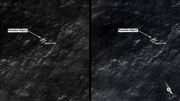
Satellite images provided by the Australian Defence Force of the floating debris.
As a result of this discovery, all of the Australian-led search efforts have now been focused on confirming the identity of this debris. Four aircraft have been deployed to the area: two Australian AP-3C Orions, one New Zealand P-3K Orion, and one US P-8A Poseidon. In addition, commercial satellites have been redirected to the area in an attempt to obtain high resolution imagery. A Royal Australian Air Force C-130 Hercules has been deployed to the region as well, and it will drop ocean current tracking marker buoys. These will assist searchers in determining where the wreckage may have ended up, and where it came from.
A merchant ship, the Norwegian-flagged Hoegh St. Petersburg, which had been contacted and diverted by RCC Australia has arrived in the vicinity, and it will assist in the search. An Royal Australian Navy warship, HMS Success, is enroute as well, though that journey will take several days. The warship is capable of recovering any debris that are proven to be from the aircraft. Britain’s Royal Navy is also sending the HMS Echo to the area.Though weather conditions in the search area are described as “moderate,” visibility is reported to be limited.
It cannot be stressed enough: while these images appear to show some sort of debris, the source of this debris is not yet known. While they may have come from MH370, they could just as easily be cargo washed overboard from a ship in the region.
Meanwhile, Malaysain authorities confirmed in their daily press conference that they are recieving assistance from France’s Bureau of Enquiry and Analysis for Civil Aviation Safety (BEA). This assistance is focused on helping the families of those on board cope with the ongoing search and lack of concrete answers. The BEA is drawing on its experience from the crash of AF447, where wreckage was not found for 5 days and the airliner’s ‘black boxes’ were missing for two years.
Update, 7:30am EDT, March 18: As the search for Malaysian Airlines Flight 370 stretches into it’s eleventh day, the search area has once again been greatly expanded. The search area now encompasses 2.24 million square nautical miles, or an area roughly the size of Australia. The area being searched has been divided into a northern corridor stretching across southern Asia and a southern corridor curving south and west from Indonesia across the southern Indian Ocean. Because of the vastness of the possible area where the aircraft might be, and the relatively limited resources of the Malaysian military, four other nations have stepped in to assist in coordinating the search. The southern corridor has been divided into two parts, with Indonesia and Australia leading the efforts in a search focused primarily in the sea. Meanwhile in the northern corridor, China and Kazakhstan are organizing the land-based search both within their borders and in neighboring countries.

The focus of today’s search by the Australian-led search team in the southern Indian Ocean.
In all, 25 nations are currently participating in the search. In addition to the countries within the region, aircraft from Japan, South Korea, New Zealand, and the United States are all actively searching. Hishammuddin Hussein, Malaysia’s defense minister and acting minister of transportation, stated this morning that he has been in contact with US Secretary of Defense Chuck Hagel about the use of additional US military assets in the search. The US currently has one Boeing P8A Poseidon aircraft and one Lockheed P3C Orion committed to the search efforts. Hishammuddin also stated that the Malaysian government has been in contact with every nation that has radar or satellite coverage of the search area, though he declined to specify which nations those might be.
Interactive: So just how hard is it to find a 210 foot long aircraft in the ocean?
These new developments come as the search becomes the longest for a missing airliner in modern times. At 11 days, the search is now longer than the 10 day search for Adam Air Flight 574, a Boeing 737-400 that crashed in the Makassar Strait on January 1, 2007. In contrast, Brazillian search teams recovered wreckage and bodies from Air France Flight 447 within 5 days of that crash in 2009.
Update, 8:00 am EDT, March 15: In an overnight, televised press statement, Malaysian Prime Minister Najib Tun Razak confirmed that the aircraft had been “intentionally diverted.” This new information comes a week after communications were lost with the missing aircraft. Malaysian officials, working teams from the FAA and NTSB as well as Britain’s Air Accident Investigation Branch (AAIB), have confirmed that vasrious means of tracking the aircraft were deliberately disabled by somebody on board. The Aircraft Communications Addressing and Reporting System (ACARS) was disabled as the aircraft crossed the eastern coastline of the Malaysian Peninsula. A short time later, the 777’s transponder was also disabled.
Following the disabling of these two systems the aircraft changed course. While the initial flight route was headed northeast, the aircraft flew west back over the Malaysian Peninsula towards the Strait of Malacca. This action has been suspected for several days, through the use of the Malaysian military’s primary radar. However, since primary radar is unable to identify which specific aircraft it is tracking, it could not be confirmed. Yesterday, utilizing satellite tracking data that was recently obtained, authorities were able to confirm that the primary radar returns were in fact from Flight 370. This information has been corroborated by the NTSB/FAA team and the AAIB team, working seperately from the Malaysian investigators but using the same data. The last communication betweenthe aircraft and the satellite occured at 8:11 am Malaysian time on March 8th (7:11 pm Eastern Standard Time).
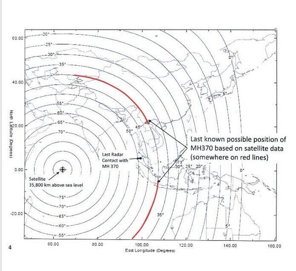
Map showing the line along which the final SATCOM transmission was made.
At this point, it is believed that once the aircraft reached a point at the northern end of the Strait of Malacca, it followed one of two possible routes. The northern route stretches from Thailand to the boarder between Kahzakstan and Turkmenistan. The southern route stretches from Indonesia to the southern Indian Ocean, somewhere to the west of Perth, Australia. Based on this new information, Malaysian investigators are concentrating on the aircraft’s crew and passengers. Specifically, they are looking to see who on board may have played a role in the intentional diversion of the aircraft.
With the confirmation of this new information, the search for the missing airliner has been significantly refocused. All search operations that were taking place in the South China Sea have ended. Where those search assets will be redeployed is currently being evaluated. The Malaysian government has also contacted the various nations over which the aircraft may have flown, and is seeking all information and radar data that they may have regarding the search. The Malaysian Foreign Ministry has invited representatives from each of these nations embassies to a briefing on today with the Malaysian and international investigative teams. Another briefing is being provided to each nation that had citizens onboard the aircraft.
Update, 10:51 am EDT, March 14: There has still been no trace of Malaysia Airlines Flight 370, although some new information has surfaced, only to be later denied by Malaysian authorities. The Wall Street Journal reported that U.S. investigators suspect the flight stayed in the air for about 4 hours past the time of it’s last known location. This is based on data automatically downloaded from the aircraft’s engines and sent to both the engine manufacturer, Rolls Royce, and Boeing as part of a maintenance and monitoring program. Assuming a 480 knot airspeed, the aircraft could have traveled 2,200 nautical miles in any direction from the point of last contact.
This latest development would broaden the scope of the investigation dramatically. It opens up a variety of outcomes including the possibility of the aircraft being commandeered and flown to an undisclosed location. It remains unclear whether the aircraft has crashed or has landed safely so all possible outcomes are still in play. However in its latest press conference, the Malaysian government has denied the validity of this report, indicating that data transmissions were last received before the aircraft disappeared from radar. The repeated conflicts of information regarding Flight 370’s disappearance have only deepened the mystery of what occurred last Saturday.

Update, 8:00 am EDT, March 11: Search and rescue crews have now concentrated their search on the Strait of Malacca, off the western coast of the Malay Peninsula. This comes after the first several days of searching in the Gulf of Thailand came up fruitless. Malaysian authorities believe that the airliner may have attempted to return to Kuala Lumpur International Airport after it dropped off of controllers radar screens.
Malaysian Ailrines has also announced that they are changing the flight number of the affected flight. Beginning Friday, March 14, Flight 370 will become Flight 318, while the return flight from Beijing will become Flight 319. This change is in line with common airline practice to retire the number of a flight that experiences a major incident. In contrast, Air France took 7 days to change the flight number after Flight 447 crashed, while it took Asiana Airlines over 1 month to change the flight number of Flight 214.
Finally, through the wonders of modern technology, you can assist in the search from anywhere in the world that you have access to a computer. On Sunday, satellite imaging company Digital Globe trained their satellite on the area where it is believed that Flight 370 may have hit the water. The high resolution images that were obtained have been uploaded to Tomnod.com where users can search them a square at a time, tagging various types of possible debris on the map.
Update, 8:45 am EDT March 10: Now more than 60 hours into the search for Malaysia Airlines flight 370, there are still no signs of the missing airliner. Numerous reports of possible debris have all proven to be false alarms thus far. Meanwhile, the oil from the two slicks found in the vicinity of where the aircraft may have gone down were sent for analysis. In results that were released by Malaysian authorities a short while ago, the oil did not match anything that would have come from an aircraft.
Update, 11:15 pm EST March 8: After more than 24 hours, search and rescue crews still have not found any definitive signs of the missing 777-200ER. While rumors have continued to swirl all day about signs of the aircraft, including possible sightings of oil slicks in the vicinity, no signs of wreckage have yet been confirmed to the media.
As of this evening, a pair of US investigative agencies have announced their involvement. The Federal Bureau of Investigation has sent investigators to the region, as a result of there having been three or four US citizens onboard the aircraft at the time of its disappearance. The team that has been sent includes both FBI agents and technical experts. The team’s initial task will be to assist in ruling out terrorism as a cause of the incident.
Also joining in the investigative efforts is a team from the National Transportation Safety Board. Since the aircraft involved was manufactured in the United States, the NTSB’s involvement is part of standard investigative procedure. Because no wreckage has been found thus far, a formal investigation into the cause has not yet begun. However, given the time necessary to reach the part of the world where this incident occurred, the investigative team has been dispatched to be on standby. Once wreckage is found, its location will determine which nation will lead the investigative efforts. In addition to the NTSB’s own investigators, the team that has departed also includes technical advisors from both Boeing and the FAA.
Update, 3:47 AM EST March 8: Malaysia Airlines has released this update concerning the status of MA Flight 370:
Sepang, 8 March 2014: Malaysia Airlines is still unable to establish any contact or determine the whereabouts of flight MH370. Earlier today, Subang ATC had lost contact with the aircraft at 2.40am. The last known position of MH370 before it disappeared off the radar was 065515 North (latitude) and 1033443 East (longitude).
We are still trying to locate the current location of the flight based on the last known position of the aircraft. We are working with the International search and rescue teams in trying to locate the aircraft. So far, we have not received any emergency signals or distress messages from MH370. We are working with authorities and assure that all sources are deployed to assist with the search and rescue mission.
Previous coverage:
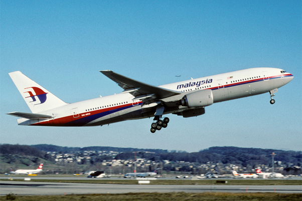
The Vietnamese media and Vietnamese Navy is now stating that Malaysia Airlines flight 370, a 777-200 operating from Kuala Lumpur (WMKK/KUL) to Beijing (ZBAA/PEK), has crashed into the South China Sea after going missing two hours after departure, though evidence of a crash has not yet been shared with the public. The flight had on board 227 passengers with a crew of 12. The aircraft’s registration is 9M-MRO.
Contact with the flight was lost by Subang Air Traffic Control on Friday at 1:40pm EST. Search and rescue teams had been activated and are currently looking for signs of the aircraft’s location, with Vietnamese Navy confirming that it went down int he water approximately 153 miles south of Phu Quoc Island.
At approximately 8:36pm EST, Malaysia Airlines shared the following statement (while the aircraft was still missing):
Statement By Our Group Chief Executive Officer, Ahmad Jauhari Yahya on MH370 Incident. Released at 9.05am/8 Mar 2014 MY Local Time
We deeply regret that we have lost all contacts with flight MH370 which departed Kuala Lumpur at 12.41 am earlier this morning bound for Beijing.
The aircraft was scheduled to land at Beijing International Airport at 6.30am local Beijing time.
Subang Air Traffic Control reported that it lost contact at 2.40am (local Malaysia time) today.
Flight MH370 was operated on a Boeing B777-200 aircraft.
The flight was carrying a total number of 239 passengers and crew – comprising 227 passengers (including 2 infants), 12 crew members. The passengers were of 13 different nationalities.
Malaysia Airlines is currently working with the authorities who have activated their Search and Rescue team to locate the aircraft.
Our team is currently calling the next-of-kin of passengers and crew.
Focus of the airline is to work with the emergency responders and authorities and mobilize its full support.
Our thoughts and prayers are with all affected passengers and crew and their family members.
The airline will provide regular updates on the situation.
The public may contact +603 7884 1234. For media queries, kindly contact +603 8777 5698/ +603 8787 1276.
It was last seen on radar near a point named BITOD over the South China Sea between Malaysian and Vietnamese airspace.

Stay tuned to this developing story…