| Identifier | FAA: PAE | IATA: PAE | ICAO: KPAE | Airport Diagram |
|---|---|---|
| Lat/Long | 47-54-25.1545N / 122-16-53.6594W 47-54.419242N / 122-16.894323W 47.9069874 / -122.2815721 (estimated) |
|
| Elevation | 606 ft. / 184.7 m (surveyed) | |
| Variation | 20E (1990) | |
| From city | 6 miles SW of EVERETT, WA | |
| Time zone | UTC -8 (UTC -7 during Daylight Saving Time) | |
| Zip code | 98275 |
| Airport use | Open to the public |
|---|---|
| Activation date | 11/1938 |
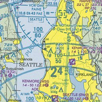
| Sectional chart | SEATTLE |
| Control tower | Yes |
| ARTCC | SEATTLE CENTER |
| FSS | SEATTLE FLIGHT SERVICE STATION |
| NOTAMs facility | PAE (NOTAM-D service available) |
| Attendance | NOV-APR 0700-2100, MAY-OCT 0700-2100 |
| Wind indicator | Lighted |
| Segmented circle | No |
| Lights | Dusk-Dawn |
| Beacon | White-green (lighted land airport) |
| Landing fee | no, LNDG FEE FOR ACFT OVER 30000 LBS GWT. |
| Fire and rescue | ARFF index B |
| International operations | customs landing rights airport |
| Runway 11/29 | |||
|---|---|---|---|
| Dimensions | 4514 x 75 ft. / 1376 x 23 m | ||
| Surface | asphalt, in good condition | ||
| Weight bearing capacity |
|
||
| Instrument approach | Runway 11: N/A | ||
| Runway 29: N/A | |||
| Runway 16R/34L | |||||||||
|---|---|---|---|---|---|---|---|---|---|
| Dimensions | 9010 x 150 ft. / 2746 x 46 m | ||||||||
| Surface | asphalt/grooved, in good condition | ||||||||
| Weight bearing capacity |
|
||||||||
| Instrument approach | Runway 16R: ILS | ||||||||
| Runway 34L: DME | |||||||||
| Runway 16L/34R | |||
|---|---|---|---|
| Dimensions | 3000 x 75 ft. / 914 x 23 m | ||
| Surface | asphalt, in fair condition | ||
| Weight bearing capacity |
|
||
| Runway edge lights | medium intensity | ||
| Instrument approach | Runway 10: N/A | ||
| Runway 28: N/A | |||
| Ownership | Publicly-owned |
|---|---|
| Owner | SNOHOMISH COUNTY 3000 ROCKEFELLER AVE. EVERETT, WA 98201 Phone 425-388-3411 |
| Manager | DAVID T WAGGONER 3220 100TH ST SW EVERETT, WA 98204 Phone 425-353-2110 |
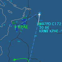
PAE Live Traffic
|
PAE Sectional Chart
|
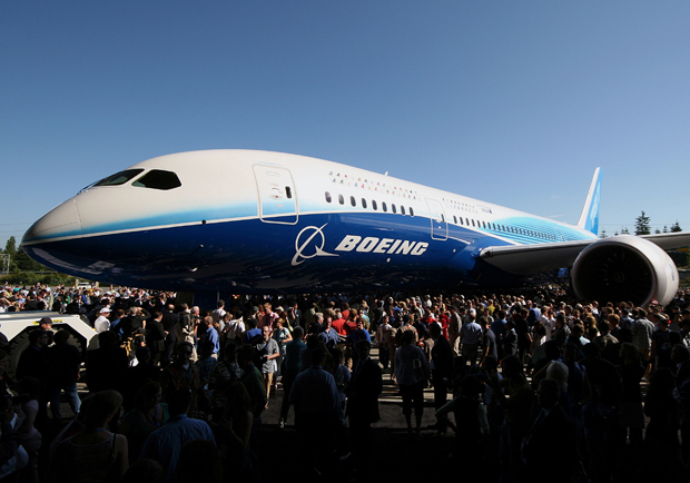
| Paine Field was originally constructed in 1936 as a Works Progress Administration project. At the time of development, it was envisioned that the Airport would create jobs and economic growth in the region by becoming one of the ten new “super airports” around the country.On July 25, 1966, The Boeing Company announced that it would build the Boeing 747, a jetliner capable of carrying nearly twice as many passengers as previous models. To build the giant jet, Boeing had to construct a facility large enough to handle the world’s largest commercial jetliner. Land just north of Paine Field was chosen to construct the new facilities, including some development on the airport itself. Both the local government and the FAA concurred with the development. Work on the massive building began in August 1966 and the first employees arrived in early 1967. The 747 made its first flight at Paine Field on February 9, 1969.
The use and expansion of the airport is currently governed by an agreement that was forged during 1978–1979 negotiations, called the Mediated Role Determination or simply the MRD. This agreement defines the role of Paine Field to be as a general aviation and aerospace manufacturing airport. In addition Snohomish County has adopted the policy of not spending funds to subsidize airlines or to pay for the infrastructure needed to support commercial air service. Local governments including Snohomish County (the airports operator), and the neighboring cities of Brier, Edmonds, Lynnwood, Mountlake Terrace, Mukilteo, and Woodway have all adopted resolutions against the use of Paine Field for commercial airline flights. |