Page 1 of 2 12 LastLast
Results 1 to 15 of 29

Thread: Northeast Weatherpocalypse Discussion 7/26/12

  1. #1
    Moderator Matt Molnar's Avatar
    Join Date
    Apr 2005
    Location
    New York
    Posts
    9,302

    Northeast Weatherpocalypse Discussion 7/26/12

    Flying to or from the northeast today? Expect delays. Lots of them. Widespread thunderstorms will continue to wreak havoc through Thursday.

    As of 12:30 PM ET...


    These are delay programs for flights arriving at the listed airports. For example, if you are flying to LGA, your flight will be held at its origin for 89 minutes.

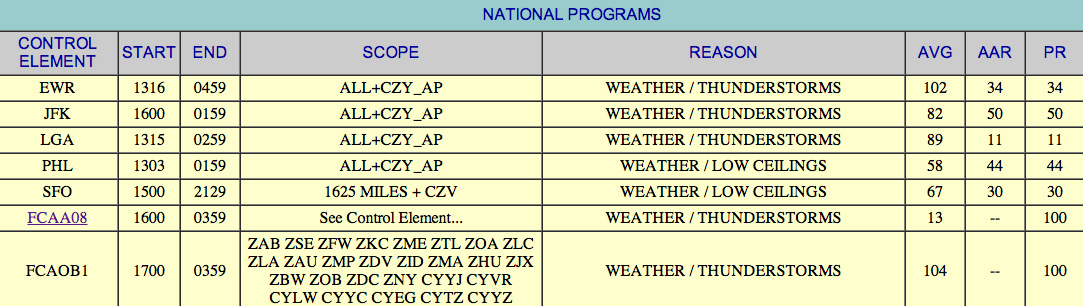
    FCAA08 is an imaginary line that runs basically east to west across the middle of Virginia. If your flight has to cross that line northbound, i.e. you're flying FLL-DCA, your flight will be held at FLL for 13 minutes.


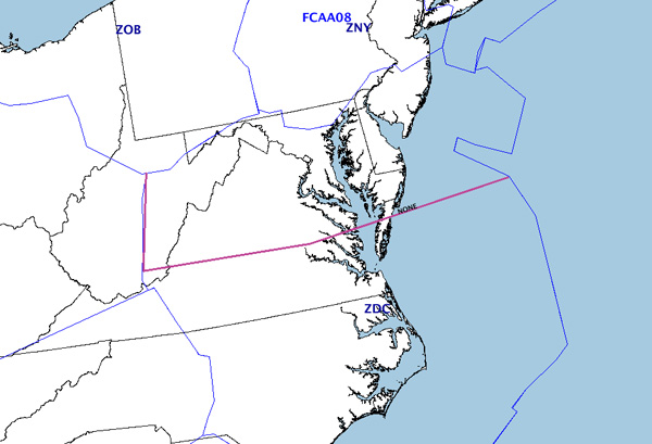
    FCAOB1 is an imaginary line that runs roughly north to south from Lake Erie through western New York, Pennsylvania and into West Virginia. If your flight has to cross that line eastbound, i.e. LAX-JFK, your flight will be held at LAX for 104 minutes.


    Note that these are all average times, and your flight could be delayed further by other factors.

    Some airlines are waiving change fees for northeast travel today, including JetBlue and Air Canada.

    Stay tuned...
    Ladies and gentlemen, this is your captain speaking. We have a small problem.
    All four engines have stopped. We are doing our damnedest to get them under control.
    I trust you are not in too much distress. —Captain Eric Moody, British Airways Flight 9

  2. #2
    Senior Member
    Join Date
    May 2009
    Location
    CYOW - Ottawa, Canada
    Posts
    360
    YOW spotter checking in here. Feel free to divert here ;)

  3. #3
    Moderator Matt Molnar's Avatar
    Join Date
    Apr 2005
    Location
    New York
    Posts
    9,302


    The "moderate" threat of severe weather has now moved to include nearly all of Long Island.
    Ladies and gentlemen, this is your captain speaking. We have a small problem.
    All four engines have stopped. We are doing our damnedest to get them under control.
    I trust you are not in too much distress. —Captain Eric Moody, British Airways Flight 9

  4. #4
    Administrator PhilDernerJr's Avatar
    Join Date
    Apr 2005
    Location
    Queens, NY
    Posts
    12,470
    As of now, the next wave of storms will strike NYC ater 7pm, echo tops being as high at 50,000ft or more.
    Email me anytime at [email protected].

  5. #5
    Moderator Matt Molnar's Avatar
    Join Date
    Apr 2005
    Location
    New York
    Posts
    9,302
    One of the models shows a bow-shaped supercell/derecho hitting NYC around 10pm. Or it could fizzle.

    Seems that today's high temps are going to be quite a bit lower than originally forecast so that might work in our favor. But there are storms popping in western PA and NY now with tornadoes.
    Ladies and gentlemen, this is your captain speaking. We have a small problem.
    All four engines have stopped. We are doing our damnedest to get them under control.
    I trust you are not in too much distress. —Captain Eric Moody, British Airways Flight 9

  6. #6
    Senior Member Fighting_falcon_51's Avatar
    Join Date
    Mar 2009
    Location
    Copiague, NY
    Posts
    1,211
    It looks like the worst of it is going to be up North in CT.

    Looks like Steve is getting what he deserves.

    It does look like it is going to be an interesting night. Stay safe everyone.
    http://www.kjpgallery.com << Photography Collection
    http://www.nyasinfo.com << Jones Beach Airshow Information (Updates continue in November)

  7. #7
    Administrator PhilDernerJr's Avatar
    Join Date
    Apr 2005
    Location
    Queens, NY
    Posts
    12,470


    As if the approaching storm that already has tornadoes was not enough, cold fronts (blue) or squall lines (the red dash & dots) that hit and converge with both a trough (orange dashes) and a warm front (red line) usually creates very ripe conditions for even more tornadoes in the armpit or "pocket" of the convergence. The above prognostic chart shows that as being... New York City. Hopefully that dry line moves and cooling evening air weakens it slightly, but we (I) won't know for a bit yet.
    Email me anytime at [email protected].

  8. #8
    Senior Member Fighting_falcon_51's Avatar
    Join Date
    Mar 2009
    Location
    Copiague, NY
    Posts
    1,211
    Looking at the new SPC products:

    T-Storm Chance: Moderate
    Tornado Chance: Between 2-5%
    Winds (50 knots or higher): 45% (30% for eastern tip of LI)
    Hail: 15%


    For those of you with scanners have your local SKYWARN frequency programmed so you can hear what is going on around you. Also have NOAA All Hazards programmed, 162.550MHz (KWO35 - NYC), 162.475MHz (WXM80- Riverhead,NY).
    Last edited by Fighting_falcon_51; 2012-07-26 at 04:42 PM.
    http://www.kjpgallery.com << Photography Collection
    http://www.nyasinfo.com << Jones Beach Airshow Information (Updates continue in November)

  9. #9
    Senior Member Cary's Avatar
    Join Date
    Sep 2007
    Location
    NJ
    Posts
    1,985
    I assume Enterprise's inflato-dome was built to withstand extreme weather?
    General Photography - Website | Instagram
    PlaneCaptures - Website | Instagram

  10. #10
    Senior Member megatop412's Avatar
    Join Date
    Sep 2005
    Location
    Philadelphia(south Jersey, actually)
    Posts
    3,283
    Quote Originally Posted by Cary View Post
    I assume Enterprise's inflato-dome was built to withstand extreme weather?

    One would think that had been taken into account, I hope...

  11. #11
    Moderator mirrodie's Avatar
    Join Date
    May 2005
    Location
    Me like the Robert Downey Jr of cooooooookies!
    Posts
    5,747
    Standby as the Intrepid may soon have a new underwater attraction...


    seriously, got a meteorologic question Phil. Is the storm is coming from the west and as it passes over NYC, do all the tall buildings have any sort of a "buffering" or lessening effect of winds coming from the north? In other words, do the buildinsg of manhattan act as a bit of a wall or barrier and soften the winds that hit ares just east of manhattan, such as rossevet island and queens/LIC?
    And I, I took the path less traveled by
    and that has made all the difference......yet...
    I have a feeling a handle of people are going to be very interested in what I post in the near future.

    http://www.jetphotos.net/showphotos.php?userid=187

  12. #12
    Senior Member moose135's Avatar
    Join Date
    Apr 2005
    Location
    Long Island, NY
    Posts
    8,067
    Just talked with a coworker who is flying back to CLT this evening (US out of LGA, I think) and his 6:59 departure has already been delayed to 9pm...he's thinking about spending another night in NYC.

  13. #13
    Senior Member megatop412's Avatar
    Join Date
    Sep 2005
    Location
    Philadelphia(south Jersey, actually)
    Posts
    3,283
    I just checked and all I see is clear blue skies...so you all be sure to send those diverting heavies down my way please, I'll be waiting on the back deck thanks

  14. #14
    Moderator Matt Molnar's Avatar
    Join Date
    Apr 2005
    Location
    New York
    Posts
    9,302
    Quote Originally Posted by Cary View Post
    I assume Enterprise's inflato-dome was built to withstand extreme weather?
    I read that the dome was damaged by last week's pre-opening storm, but not sure if it was from hail, wind, lightning, etc. If today's storms hold together, they will be worse than that.
    Ladies and gentlemen, this is your captain speaking. We have a small problem.
    All four engines have stopped. We are doing our damnedest to get them under control.
    I trust you are not in too much distress. —Captain Eric Moody, British Airways Flight 9

  15. #15
    Senior Member
    Join Date
    May 2012
    Posts
    384
    First go around is official. Delta 216 pulled up going for 22left, right in front of me. I happened to be going to see where "the mounds" we're for the first time, on the way to an appointment out on long island. A heavy suddenly pulled up just as I was turning around to get on my way. Wind shear and heavy turbulence at approx 100 feet was the cause. They're switching to the fours possibly for the night, depending on where these winds force things.

    First time I've seen a go around from that close. I hope everyone's ok...but that was pretty damned impressive to see.

Bookmarks

Posting Permissions

  • You may not post new threads
  • You may not post replies
  • You may not post attachments
  • You may not edit your posts
  •