This article is the first from one of our newest contributors, Meteorologist Adam Daum, whom we are very excited to have in our ranks. If your travels ever generate any weather questions, email us at [email protected] and maybe we can write an article about it! –Phil Derner, Founder
Although turbulence, icing and gusty winds are each formidable threats to aviation each by themselves, thunderstorms bring all of these risks together (plus others) and pose perhaps the most formidable hazard to flight operations. Ranging in size from just a few miles to thousands, and growing sometimes to over 50,000 feet tall, thunderstorms are most commonly found in the mid-latitudes; where warm and cold air generally meet. The energy created by just one average storm exceeds that which was produced by the atomic bombs detonated over Japan! Understanding how these complex powerhouses work begins by looking at two fundamental concepts (heating and moisture) that together produce these mammoth clouds.
As the sun shines down upon us, it heats the earth’s surface unevenly. As a result, there are pockets of air that are warmer than others. Since we know that hot air rises, warmer air pockets tend to try and rise above the colder air around them (An easy way to visualize this is to turn on your oven’s range and see what happens to the air above it. The air being heated appears to be blurred and rising; this air is lighter [less dense] than the air around it and is thus rising above the colder air). The other important piece of the puzzle is the water dissolved in the air, or as we think of it, humidity. Depending on its temperature, air has more or less capacity to retain water; the warmer the air, the more water it can hold (An easy way to visualize this is to think about when a cold beverage is poured on a hot day and the glass suddenly fogs up on the outside. The cold beverage quickly cools the air around the glass and thus, that air loses some ability to retain water. That water is deposited on the glass as condensation).
When we combine these two ideas, we get cloud formation! Warm and moist parcels of air rise above cooler and drier areas. As that air rises and cools, the retained water begins to condense out as water vapor, forming clouds. The process of condensation actually releases some energy itself in the form of latent heat, which helps keep the newly formed cloud a bit warmer than its surroundings. This important fact helps keep the cloud rising and growing. The more moisture and heating you have, the bigger and taller these clouds tend to get. (With this in mind, one could understand why thunderstorms tend to form over the tropics, since there is an abundance of available heat and moisture)
As we know, not all clouds become thunderstorms. In fact, most clouds we see in the skies are rather benign. Thunderstorm growth is most often stunted by a lack of moisture or a layer of warm air located above a layer of cooler air (what we call a temperature inversion). We normally assume the atmosphere to get colder as we go higher, but that is not always the case. Therefore, in an atmosphere with warmer air trapped aloft, a rising parcel of warm/moist air will approach this anomalously warm area and stop growing and spread out, since it is no longer warmer than its surroundings.
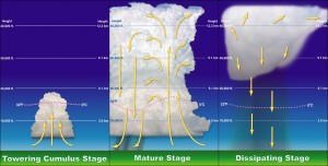
Now that we have an idea of how the clouds form, we can take a look at the common life cycle of a thunderstorm. It all starts with the “Cumulus Stage”, where rising warm/moist air condenses to form the commonly-seen “fair weather” cumulus cloud. These clouds often grow only to be a few hundred or thousand feet tall and seldom yield any rain. However, if the dynamics are conducive, these clouds will continue to grow, transforming into Towering Cumulus Clouds (TCU) that reach heights of over 20,000 feet. Light to moderate rain is often reported during this phase and it’s at about this time that the cloud begins to exhibit real signs of thunderstorm activity.
The storm enters its “Mature Stage” when the rising air can no longer ascend, reaching a warmer layer and spreading out. By this stage, the cloud is referred to as a cumulonimbus cloud, reaching heights of between 40,000-60,000 feet, and often takes on the shape of an anvil as it spreads out. Massive amounts of water vapor in the cloud begins to coalesce and descend towards the ground, starting off as ice and then melting into rain as it falls. The falling rain and ice creates downward winds (downdrafts) and that is one reason why windy conditions are often reported underneath and around thunderstorms. The rising air (updrafts) continues to feed the storm on the periphery of the downdrafts and a cycle forms within the cloud. Rain and ice are constantly rising and falling,with hail being created in the strongest of storms. The mixing and separating of lighter and heavier ice and rain are also thought to be the driving force for lightning formation. Though not fully understood, it is believed that heavier slushy ice (negatively charged) collects near the bottom of the cloud, while lighter ice crystals (positively charged) collects at the top (Hail, lightning and other features of the most severe thunderstorms will be discussed in a subsequent post).
Thunderstorms tend to transition into the final “Dissipating Stage” when the falling rain and downdrafts overtake the rising warm air. Though other factors can help sustain thunderstorms for hours at a time, a single-cell storm cycle usually takes just 20-30 minutes to transpire. Without moist warm air feeding the cloud, the process cannot perpetuate itself and the thunderstorm will simply rain itself out.
So when you’re standing at the airport, beach ball in-hand, angry that storms are delaying your trip to tropical climates, know that the delays you’re experiencing are due to some pretty serious stuff taking place in the skies above. As annoying as having that first margarita 2-3 hours later is, keeping you safe is always top priority.
Adam Daum is a Senior Aviation Meteorologist with WSI and is embedded within the System Operations Center of a major NY-based airline. Hailing from Oceanside, NY, Adam graduated from Cornell University in 2005 and spent the next 5 years working at NBC News’ “The Today Show” and NY1 News as a weather producer. His love for Aviation (and Israel) led him to join the Israeli Air Force in 2010 and work as an Aviation Forecaster for the Israel Meteorological Service from 2011-2013.


