When most people hear the words “Tropical Storm” or “Hurricane,” their first thought is to head for cover. However, for a small group of people, it’s time to head to work. These are the crews that fly and man the aircraft of the National Oceanic and Atmospheric Administration (NOAA) better known as the Hurricane Hunters.
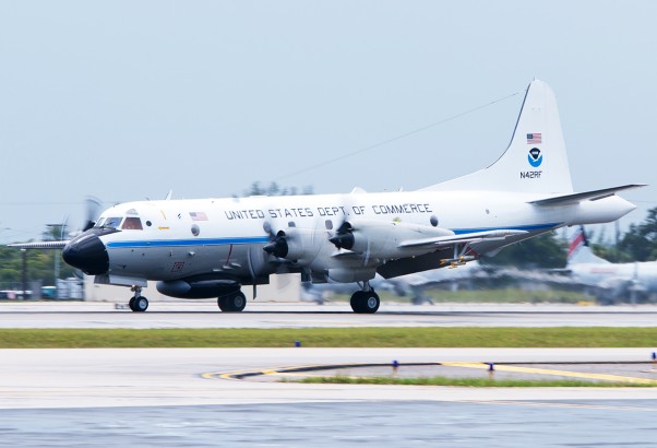
NOAA operates two Lockheed WP-3D Orions (N42RF “Kermit” and N43RF “Miss Piggy) and one Gulfstream G IV (N49RF “Gonzo”) as Hurricane Hunters out of MacDill Air Force Base in Tampa, Fla. Additional support is supplied by Lockheed WC130-J aircraft of the 53rd Weather Reconnaissance Squadron of the Air Force Reserve based at Keesler Air Force Base in Biloxi, Miss.
The different aircraft in the Hurricane Hunter fleet serve unique roles. The P-3s are flown at low altitudes directly into the storms to gather wind speed and direction, temperature and pressure data. In addition to instruments on the aircraft themselves, the numbers are obtained by dropping dropsondes through the bottom of the aircraft that transmit the data to gathering equipment on the aircraft. The Gulfstream G- IV flies at high altitude to gather data regarding winds and conditions above and around the storm, also by using dropsondes.
We were recently able to spend a little time with Kermit as it returned from a reconnaissance flight to study Tropical Storm (later Hurricane) Leslie and Hurricane Michael.
The day had started for the crew with a 1:50 am departure from their home at MacDill Air Force Base to Fort Lauderdale/Hollywood International Airport. That was followed by a 4:15am departure out over the Atlantic Ocean for a 9 hour round trip sortie arriving back at 1:15pm. Following the landing on rainy runway 9L, Kermit rolled along Taxiway Alpha to the parking at the National Jets FBO. The weary crew unloaded their equipment and headed into the FBO and a local hotel.
Kermit’s break would be be short-lived, however, leaving just after 4:00pm for another 7+ hour sortie back to the weather. During its short time on the ground though, we were allowed access to the aircraft during which time, we were able to get photographs of the interior and get a short discussion with Flight Director Ian Sears. When asked about the ride in Tropical Storm Leslie, he said it was pretty smooth – the seat beltrs were on for a short part of the trip. He went on to say that when flying in a hurricane, the ride is also pretty smooth, with, depending on the strength of the storm, some small to moderate buffeting.
We hope to spend some more time with these crews as they fly in and out of Fort Lauderdale in support of hurricane research.


